[Translate to Englisch:] „Digital analysis and visualization of the 18th Dynasty delta residence at Tell el-Dab'a, Egypt“
Project Jubiläumsfonds 17916, Österreichische Nationalbank
at VIAS, Vienna Institute for Archaeological Science
Duration: December 2018 – December 2020
Project director: Ass. Prof. Dr. Irmgard Hein
Collaborator: Dr. Sandra Müller
[Translate to Englisch:] Inhalt
- [Translate to Englisch:] Abstract Deutsch/English
- The Archaeological Site Tell el-Dabʿa
- Aim of the Project
- Applied methodology
- Literature
- Cooperating Institutions
- List of publications
(Kopie 1)
Abstract
Deutsch
Im Mittelpunkt des Projektes steht die digitale Erfassung und Analyse von bisher unbearbeiteten Daten aus den Ausgrabungen des ÖAI Kairo (Österreichisches Archäologisches Institut Kairo) im östlichen Nildelta. Das hier bearbeitete Areal gehört zum sog. kleinen Palastbezirk der frühen 18. Dynastie (15. Jh. v. Chr.) bei ʿEzbet Helmi und liegt innerhalb des weitläufigen antiken Stadtgebietes von Auaris, der einstigen Hyksos-Hauptstadt, heute bekannt als Tell el-Dabʿa. Konkret handelt es sich um Daten zu Baubefund und Fundmaterial aus den Grabungsflächen H/I, H/IV und H/V, aus dem Bereich und der Umgebung eines Palastunterbaus, der insbesondere aufgrund der Funde von minoischen Wandmalereien Aufmerksamkeit in der Öffentlichkeit erlangt hat. Der erhobene Datenbestand wird innerhalb einer GIS-referenzierten Datenbank erfasst und dient zur Aufschlüsselung der Stratigraphie mittels Harris-Matrix, ebenso wie zur Determinierung der Architekturreste anhand der Fundkontexte. In Folge davon sind der Aufbau stratigraphischer 3D-Modelle und deren Visualisierung in der antiken Landschaft mit Rekonstruktions¬vorschlägen vorgesehen. Die gewonnenen Daten und Ergebnisse werden letztlich der Langzeitarchivierung im ACDH-Archiv (Austrian Center for Digital Humanities) an der ÖAW zugeführt.
Das vom Jubiläumsfonds der Österreichischen Nationalbank (ÖNB) geförderte Projekt Nr. 17916 ist an der Historisch Kulturwissenschaftlichen Fakultät der Universität Wien bei VIAS (Vienna Institute for Archaeological Science) angesiedelt und wird in Kollaboration mit dem Ludwig Boltzmann Institute für Archäologische Prospektion und Virtuelle Archäologie (LBI ArchPro). durchgeführt. Weitere Unterstützung ist gewährleistet durch das Institut für Ägyptologie an der Universität Wien, sowie dem Institut für orientalische und europäische Archäologie (OREA) und das Österreichische Archäologische Institut, beide an der Österreichischen Akademie der Wissenschaften (ÖAW).
English
This project focuses on the digital recording and the analysis of data from field work in the Eastern Nile Delta by the Austrian Archaeological Institute Cairo (ÖAI). Project data comes from a palace district of the early 18th Dynasty (15th century B.C.) at 'Ezbet Helmi. In ancient times it was part of the large urban area of the town of Avaris, the capital of the Hyksos; today, the archaeological site is known as Tell el-Dab'a.
The data corpus reassembles information about the architectural remains and the find materials from field areas H/I, H/IV and H/V, which encompass the substructure of a palace and surrounding districts. The plot has gained public attention due to the finds of Minoan wall frescoes in the area.
All data is collected within a Geo referenced database, that serves the creation of a Harris-Matrix for the itemisation of the stratigraphy. Furthermore, the corpus is used for the determination of the architectural remains via the analysis of the find contexts. As a result of this process, stratigraphic 3-D models are provided, as well as visualisation of the ancient landscape using hypothetical models. Finally, the acquired data and results will be stored in the archives of the ACDH (Austrian Center for Digital Humanities).
The project (no. 17916) is funded by the Anniversary Fund of the Oesterreichische Nationalbank (OeNB), and hosted at the VIAS (Vienna Institute for Archaeological Science) in the Faculty of Historical and Cultural Studies at the University of Vienna. It is conducted in Collaboration with the Ludwig Boltzman Institute for Archaeological Prospection and Virtual Archaeology (LBI ArchPro). Support is provided by the Institute for Egyptology at the University of Vienna, and the Institute for Oriental and European Archaeology (OREA) and the Austrian Archaeological Institute (ÖAI), both at the Austrian Academy of Science.
The Archaeological Site – Tell el-Dab'a
The ancient urban site of Tell el-Dab'a/Avaris is located around 140 km north-east of Cairo, in the district of Faqus within the province Sharqiya. The site has a long history of occupation and is well known as a zone of urban development. Continuous settlement activity can be traced throughout the entire 2nd Millennium B.C. beginning in the early 12th Dynasty, stretching over the Middle and the New Kingdom, until the Ramesside Period. Traces of later settlement activities from the 1st Millennium B.C. were also detected. The area became particularly well known as the capital by the name Avaris during the Hyksos period (2nd Intermediate Period).
The ancient settlement area covered about 2 km² and extended along the course of a former main delta branch of the Nile (the so called Pelusiac Nile arm), which had silted up by the first millennium B.C. (see Map 1). Today, the former urban compound is invisible in the agricultural landscape, and was cut in the middle of the 20th century A.D. by construction of the Didamun canal and a parallel main road on an embankment. The settlements of 'Ezbet Helmi (area H/I-VI), 'Ezbet Rushdi (area R/I-III) and Tell el-Dab'a (area A/I-V, and F/I-II) are modern villages in the area.

Example of ceramics register, inv. no_7863R
The Austrian Archaeological Institute (ÖAI) began excavations in 1967. Over the years, these have yielded settlement structures, tombs, temples and palaces, showing the growth of a well-established society during the Second Intermediate Period and in the following early New Kingdom. Contact to the eastern Levant and the eastern Mediterranean are deduced from many imported finds, such as pottery or other objects; fragments of Minoan-wall paintings from 'Ezbet Helmi indicate an Aegean connection (Bietak et alii 2007).

Area H/IV, Beginning of the field work, March 1993

Area H/IV, excavation activity, spring 1993
Today, only a small area of the former urban compound is protected by the Egyptian Ministry of Antiquities at the site of Tell el-Dab'a, whereas a large part of the ancient habitation area is situated in agricultural fields and the preservation of the layers is endangered by modern farming and house building activities.
The fieldwork by the Austrian Archaeological Institute (Cairo Branch) has resulted in a large amount of recorded data and numerous publications, in particular for the site of Tell el Dab'a although the site of 'Ezbet Helmi is not yet fully published. This project was developed to analyze three field areas around (the so called small) platform F (Bietak 2007) according to the sequence of the layers, the architectural remains and the finds within their geospatial and temporal relations.
Aim of the project
The scope of the project is the investigation and analysis of the data from the excavation areas H/I, H/IV and H/V. The site includes a part of a former town enclosure and the mudbrick platform F, as well as an adjacent habitation and housing areas. Platform F is located at the north-western edge of the ancient town towards the bank of the Pelusiac Nile branch. A small settlement and workshop area from the early New Kingdom was detected to the north-east of the platform. To the south-west, contemporary storerooms were attached to the platform, cutting into earlier levels from the Second Intermediate Period.

“Kastenmauerwerk “; foundation structures of platform F, spring 1993, location H/IV-o/19, planum 5.

Part of the workshop, in H/IV-k/3, planum 5.
The recording of the archaeological data and their organization within a geo-referenced database is a major task of the project. A systematic collection of data is built up to be used for the analysis and visualization of the site, the records document the early 18th Dynasty comprising a palatial structure, as well as economic and administrative installations in an urban context from the mid of the second Millennium B.C.
From a historical point of view, the architectural remains - dominated by the huge mudbrick platform - point to the re-establishment of the Egyptians in the eastern Nile Delta after the expulsion of the Hyksos. Additionally, the finds let us assume the revival of the Egyptian connection to the eastern Mediterranean at the beginning of the Late Bronze Age (2nd half 2nd Millennium B.C.), which we can observe in several phases of occupation.
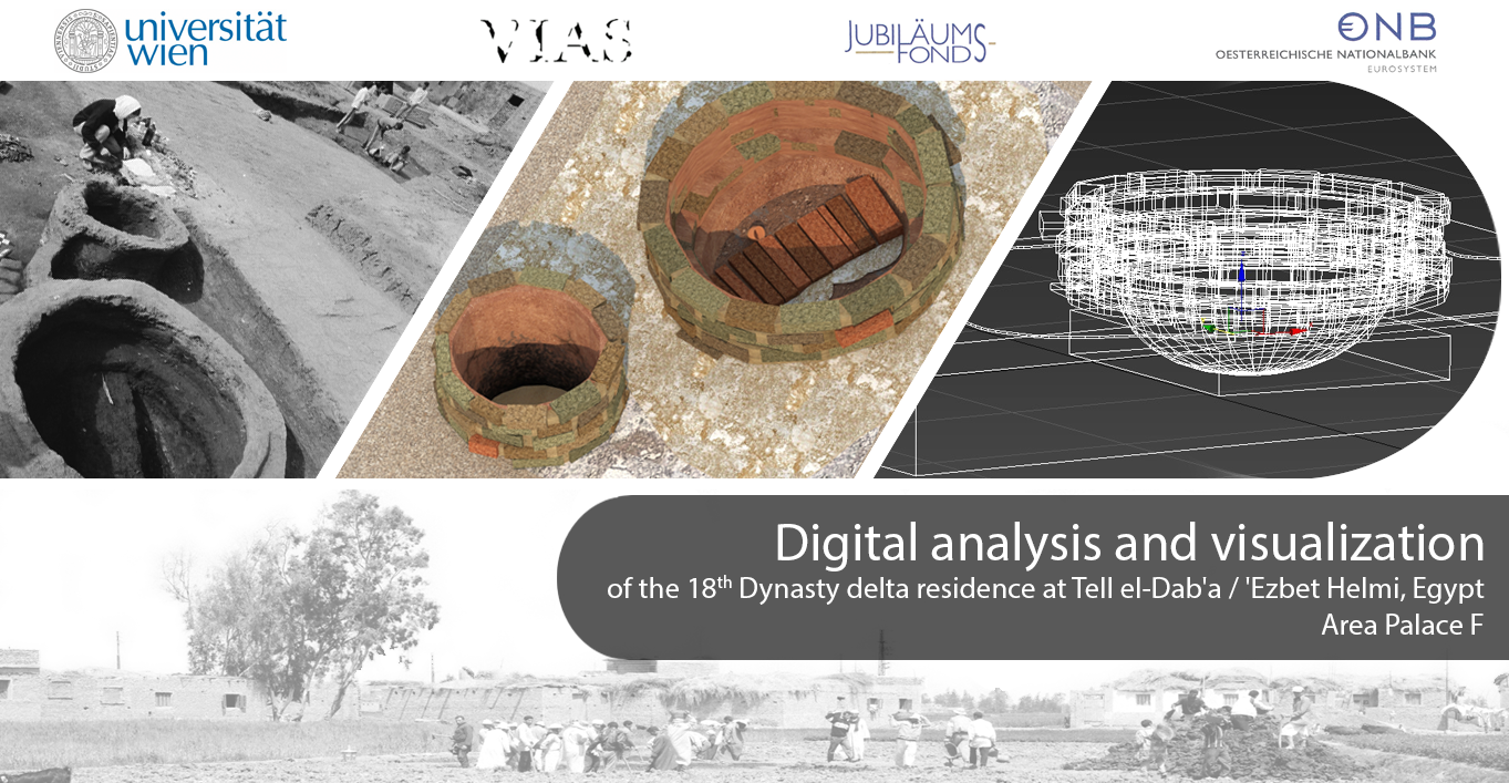
The finds, in particular the pottery, are an important category to study the development of the material culture from the end of the Hyksos period (~1538 B.C.) to the 18th Dynasty. The analysis of the data enables us to establish a Harris Matrix for the interpretation of the stratigraphic sequence in detail as well as the stratigraphic analysis leading to the visualization of the former remains and the layers, including 3D models of the structures.
Applied methodology
1) Preparations
In a first step, we have already cleared the organization and proper rights to the data regarding ethical, legal and copyright issues. The available material is collected and sorted according to different categories, such as field records, field drawings or photographs taken during the excavation, field protocols, object find slips, register books, drawings of pottery and other objects, and photos of objects. All documentation is digitized and compiled following state-of-the-art international standards concerning file formats, file names and image resolution.

Field drawing: H/I – i/25, planum 2, 10.11. 1989; rec. I. Hein, W.v. Haarlem

Example of field records, H/I - f /27; trench 2, planum 3, stratum c – d

Example of ceramics register, inv. no 7863R

Inked drawing, inv. no 7863R

Photographic documentation, inv. no 7863R
2) GIS related database
All collected data is then transferred into a spatial database using ArcMap GIS, including the upload and georeferencing of all images (field drawings and photos) according to the coordinates in the excavation grid system; furthermore, all magnetic survey data from former field seasons are integrated. Shape files are then defined according to the feature classes (such as walls, pits, layers, etc.), before a re-interpretation of the features is made by redrawing.

Construction design of an area in 2D GIS
The workflow for the digitalization includes the international standards for metadata and object identifiers, developed in collaboration with the LBI for digitizing excavation records.

GIS database
Within the GIS database, each feature is defined by the entries from the field diaries, maps, records, possible publications, drawings and photos. Information from other external databases, such as pottery inventory, sherd collections, object register, or the bone registration, are imported as well, and/or partly linked. The metadata to the entries provide transparency and retracing of the material.
The acquired data are used for further analyses, leading to a meticulous interpretation of the archaeological features within the area, and serve as the established base for the reconstruction of the levels and for a virtual 3D model.
3) Find materials
The integration of the find materials, ceramics, small size objects and other materials, are of particular importance for the interpretation of the archaeological context. Here the precision of find positions within the layers, as well as the composition of find deposits are significant for the functional identification of the entities. Finally, the find material determines the function of the architectural remains, as well as the typological analysis of the material supports to establish a chronological sequence of the features and the layers.

Mapping the finds
Literature
Bietak, M. / Dorner, J. / Hein, I. / Janosi, P.
1994 Neue Grabungsergebnisse aus Tell el-Dab'a und 'Ezbet Helmi im östlichen Nildelta 1989-1991, Ägypten & Levante Bd. 4, 9-80.
Bietak, M. / Hein, I.
2001 The Context of White Slip Wares in the Stratigraphy of Tell el-Dab'a and some Conclusion on Aegean Chronology. In: V. Karageorghis (Ed.), The White Slip Ware of Late Bronze Age Cyprus. Proceedings of an International Conference. Organized by the Anastasios G. Leventis Foundation, Nicosia, in Honour of Malcolm Wiener. Nicosia, 29th-30th October 1998. (DÖAW 20), Wien 2001. 174 – 194.
Bietak, M. / Marinatos, N. / Palivou, C.
2007 Taureador scenes in Tell el-Dab'a (Avaris) and Knossos. DÖAW XLIII, UZK XXVII.
Bietak, M.
2017 Harbours and Coastal Military Bases in Egypt in the Second Millennium B.C.: Avaris, Peru-nefer, Pi-Ramesse, in: H. Willems, J.-M. Dahms (eds.), The Nile. Natural and Cultural Landscape in Egypt, Bielefeld 2017: transcript Verlag, 53-70.
Hein, I.
1993 Erste Beobachtungen zur Keramik aus 'Ezbet Helmi, Ä&L 4, 25-27.
1998 'Ezbet Helmi - Tell el-Dab'a: Chronological Aspects of Pottery. Proceedings of the 7th International Congress of Egyptology. Cambridge 1995. OLA 82, 1998. 547 – 554.
2001A On Bichrome and Base Ring Ware from Several Excavation Areas at 'Ezbet Helmi. In: The Chronology of Base-Ring and Bichrome Wheel-made Ware. Ed. By P. Aström. KVHAA 54. Stockholm 2001. 231 – 247.
2001B Kerma in Auaris. In: Begegnungen, Festschrift für E. Endesfelder, H. Priese W.F. Reineke und S. Wenig. Eds: C.-B. Arnst, I. Hafemann, A. Lohwasser. Leipzig. 199 – 212.
2002 Untersuchungen und vorläufige Bilanz zur Keramik aus 'Ezbet Helmi, speziell Areal H/V. Ä&L XI, 121-147.
2007 The Significance of the Lustrous Ware Finds from 'Ezbet Helmi/Tell el-Dab'a (Egypt), in: I. Hein (Ed.), The Lustrous Wares of Late Bronze Age Cyprus and the Eastern Mediterranean, CChEM XIII, Vienna 79 - 106.
2009 A Contribution from Tell el-Dab'a/'Ezbet Helmi to the Cyprus Connection at the Turn of the Middle Bronze Age to Late Bronze Age. In: Proceedings of the International Conference EGYPT AND CYPRUS IN ANTIQUITY, Nicosia, 3-6 April 2003. Edited by D. Michaelides, V. Kassianidou, and R. S. Merrillees. OXBOWBOOKS, Oxford and Oakville, 29-39.
2013 For practical use – an example of recycling in the ancient world. In: Institutiones historier. En vänbok till Gullög Nordquist. Ed. by E. Weiberg, S. Carlsson & G. Ekroth. Uppsala 2013. 209-212.
2018 Second Thoughts on Cypriot Pottery and First Appearances, in: The Hyksos Ruler Khyan and the Early Second Intermediate Period in Egypt: Problems and Priorities of Current Research. Proceedings of the Workshop of the Austrian Archaeological Institute and the Oriental Institute of the University of Chicago, Vienna, July 4 – 5, 2014, I. Forstner-Müller – N. Moeller (eds.)¸ Ergänzungshefte zu den Jahresheften des Österreichischen Archäologischen Institutes, Heft 17, 125 – 142.
Kucera, M. / Neubauer, W. / Müller, S. / Doneus N.
2016 Old Excavation Data – What Can We Do? The Tell el-Daba Archaeological Information System: adding the forth dimension to legacy datasets of long-term excavations (A puzzle in 4D). 10th ICAANE, 25th-29th April 2016, Vienna, OREA, Austrian Academy of Sciences, Abstract, Booklet, 275f.
Müller, S. / Kucera , M. / Neubauer, W. et al.
in print The Tell el Daba Archaeological Information System: adding the fourth dimension to legacy datasets of long-term excavations (A puzzle in 4D); in: Aspöck, E., M. Kucera, K. Kopetzky and S. Štuhec (eds.), “Old excavation data – what can we do?" Proceedings from the workshop at the 10th ICAANE Conference, Vienna, 28. April 2016. OREA Series, Austrian Academy of Sciences Press.